
Latitude and longitude diagram. Geographic coordinate system.
If you have ever tried to pinpoint the exact location of a certain place on a map, you must have come across Latitude, Longitude, and Meridian concepts. While some might find these words quite confusing, it is important to understand their meanings to comprehend the geographical coordinates better. This blog post will focus on explaining these three terms and what they mean about mapping. So, if you are ready to immerse yourself in all things geographic and geospatial, read on!
What is Latitude?
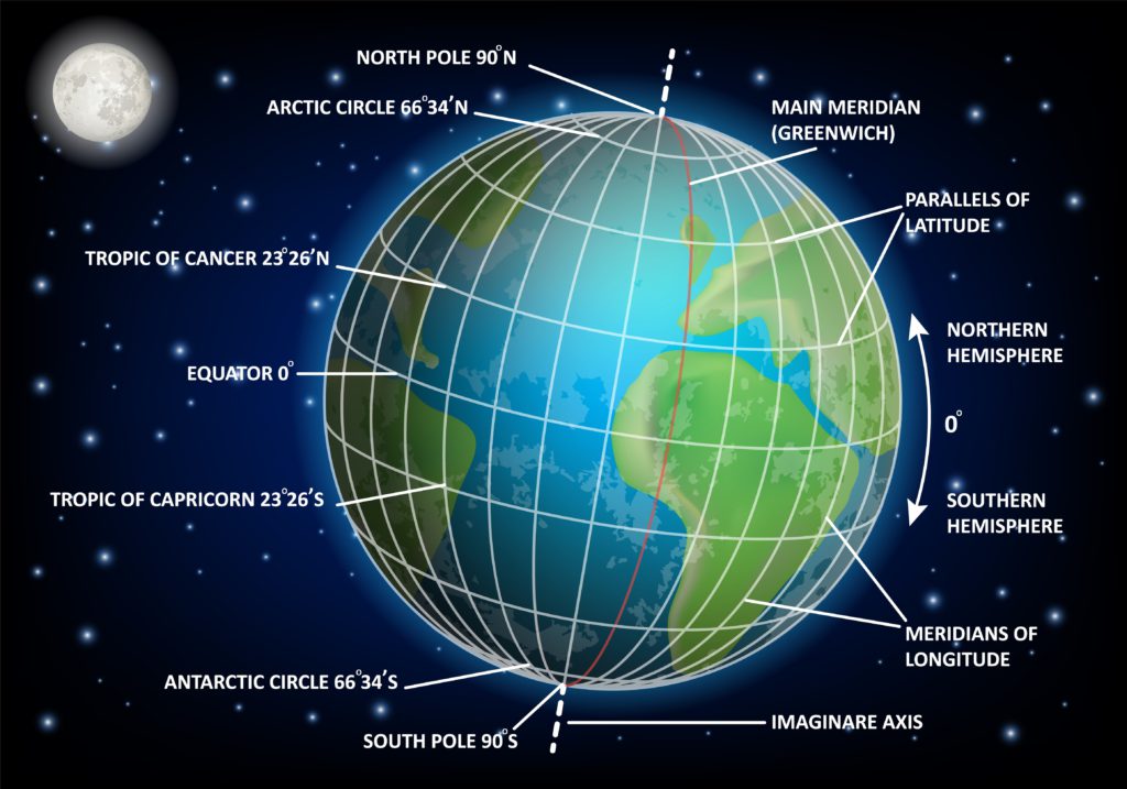
The latitude of a place is a measure of its distance north or south of the equator. This is the most commonly used measure to describe a location’s position on Earth. The equator is the imaginary line around the planet that runs through the center of the Earth and is equidistant between the two poles. The north and south latitudes are the lines that mark the top and bottom of an imaginary vertical plane that slices through the Earth and touches the center. If you want to know your latitude, you must measure the distance from the equator to your place. In other words, latitude is a horizontal measurement that specifies the position of a place north or south of the equator. The equator has a latitude of 0°, the North Pole is 90° north of the equator, and the South Pole is 90° south of the equator.
What is Longitude?
Longitude is an east-west measurement of the position of a place on the globe. This is commonly measured as the angular distance of a place from an imaginary vertical line called the Prime Meridian that goes through the Royal Observatory in Greenwich, London. If you want to know your longitude, you must measure the distance from the Prime Meridian. In other words, longitude is a vertical measurement that specifies the position of a place east or west of the Prime Meridian. The Prime Meridian has a longitude of 0°. If you go east from the Prime Meridian, you increase your longitude; if you go west, you decrease it.
What is Meridian?
A meridian is any line of longitude that goes through the center of a given place. A meridian can be a line of latitude or longitude. The Prime Meridian is an imaginary line of longitude that runs through the Royal Observatory in Greenwich, London. If you have ever used a map, you might have noticed the degrees of latitude and longitude on it. These are used to specify the location of a place on the Earth’s surface. The degrees of latitude is from the equator to the poles, whereas the degrees of longitude are from the Prime Meridian to the International Dateline.
Prime Meridian
The Prime Meridian is an imaginary line that separates east and west. The Prime Meridian is the starting point of longitude measurements. It is also the line on which 0° longitude is located. The Prime Meridian is located at the Royal Observatory in Greenwich, London. If you look at a world map, you will see that the Prime Meridian is the Greenwich line that divides the eastern and western hemispheres. The Prime Meridian was established as the starting point of longitude measurements in 1884 at the International Meridian Conference. Before then, various nations had their own starting points for longitude. Since the Prime Meridian crosses all continents, using it as the common longitude point made calculating geographic data easier.
Latitude and Longitude Together in One Equation
If you want to understand the relationship between latitude and longitude, you must know how to write an equation for their relationship. The equation for calculating latitude and longitude is as follows: Latitude (LAT) = 90 – (LONG/100) For example, if the longitude of a place is 73°W, we will have: LAT = 90 – (73/100)
Meridians: A Guide to Comprehending Longitudes and Latitudes
If you understand the difference between longitudes and latitudes and how they are related, it is important to note that all meridians run through the centre of the Earth. This means that if you draw a straight line through the centre of the Earth, it will be a meridian. The vertical line on a globe that separates east and west is called the Prime Meridian. Meridians are often used with longitudes to specify different locations on Earth.
Circles of Latitude
The latitude of a given place determines the angle between the equator and that place. All places on the same latitude have the same angle. As we mentioned before, the angle between the equator and a place on the same latitude is known as the latitude angle. The latitude of a place is also often referred to as the circles of latitude. This is because these circles look like a series of parallel lines extending from the equator toward the poles. The equator is considered to be 0° latitude since it is the line that marks the intersection of the Earth’s surface with the equatorial plane. Similarly, the North and South Poles are 90° latitude since they are the lines that mark the intersection of the Earth’s surface with the polar planes.
The five primary parallels(lines of latitude)delineating a hemisphere’s divisions are called meridians. Meridians are important for establishing timezones, as they demarcate half of the circle’s interior. The Earth, Sun, and climate are interconnected via these five important parallels. These same five parallels delineate these five geographic regions. The Arctic Circle defines the northernmost edge of the North FrigidZone. The Tropic of Cancer defines the northern edge of the North temperate zone. The Equator divides the earth into northern and Southern hemispheres, and the tropical regions around the Equator are limited to the north by the Tropic of Cancer and to the south by the Tropic of Capricorn. The Tropic of Capricorn encloses the South Temperate Zone with the AntarcticCircle, the southernmost boundary of the South FrigidZone.
Tropic of Cancer
A tropic is an imaginary line that extends from the tropic of cancer to the tropic of Capricorn. The tropic of Cancer is found in the northern hemisphere, while the tropic of Capricorn is found in the southern hemisphere. Both these imaginary lines are parallel to the equator. The Tropic of Cancer and the Tropic of Capricorn are significant because they mark the northernmost and southernmost areas where the sun can be directly overhead at least once a year. These two imaginary lines are the points where the sun appears to cross the equator. The sun’s path across the sky is perpendicular to the Earth’s axis. When the sun is directly over one of these lines, its path across the sky will be parallel to the equator.
Tropic of Capricorn
A tropic is an imaginary line that extends from the tropic of cancer to the tropic of Capricorn. The tropic of Cancer is found in the northern hemisphere, while the tropic of Capricorn is found in the southern hemisphere. Both these imaginary lines are parallel to the equator. The Tropic of Cancer and the Tropic of Capricorn are significant because they mark the northernmost and southernmost areas where the sun can be directly overhead at least once a year. These two imaginary lines are the points where the sun appears to cross the equator. The sun’s path across the sky is perpendicular to the Earth’s axis. When the sun is directly over one of these lines, its path across the sky will be parallel to the equator.
Conclusion
Latitude, longitude, and meridians are three important concepts related to mapping. While latitude is a measurement of distance north or south of the equator, longitude is a measurement of distance east or west of the prime meridian. Meridians are imaginary lines that cut through the center of the Earth, and the prime meridian is an imaginary line used as the starting point for longitude measurements.

Get exclusive info about Cirsy.com Updates
Subscribe to our newsletter and don’t miss anything.
We promise we will not spam you!
Follow CIRSY
#spacescience
